
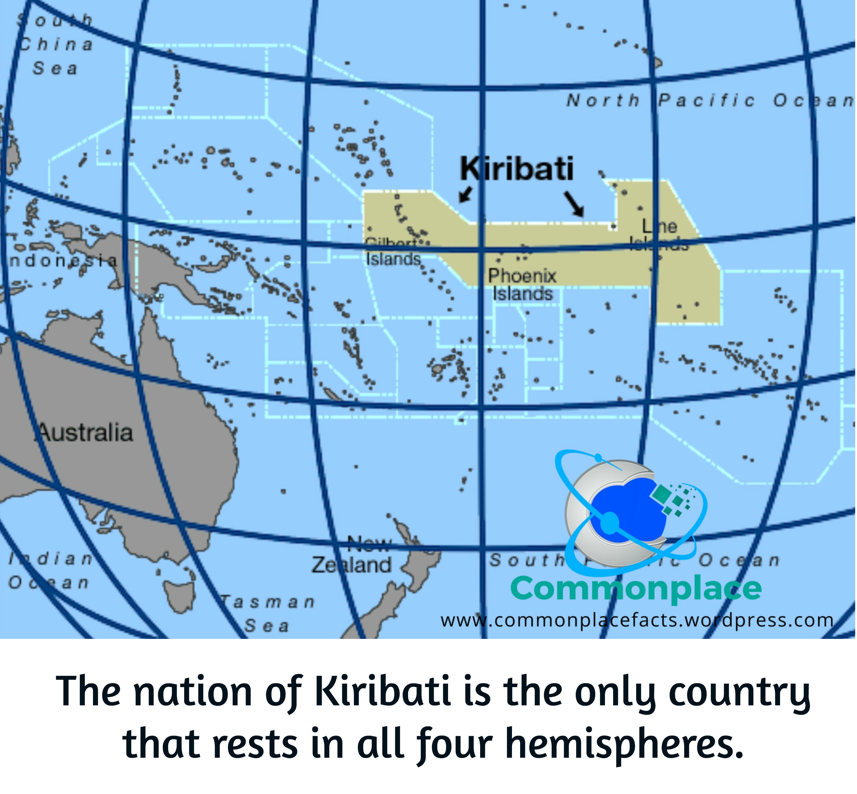

Most countries are content to occupy one hemisphere. Some ambitious nations manage two. The Republic of Kiribati looked at this perfectly adequate arrangement and somehow ended up in all four.
Its islands lie north and south of the Equator and east and west of the 180th meridian. That places parts of Kiribati in the Northern, Southern, Eastern, and Western hemispheres.
Then, as though geographically overachieving were not enough, Kiribati persuaded the International Date Line to make an enormous detour around it. As a result, the country manages to occupy all four hemispheres while keeping all its citizens on the same calendar day.
Kiribati is what happens when geography, politics, and timekeeping are all assigned to the same committee.
Where Is Kiribati?
Kiribati—pronounced approximately Kiri-bass—is a Pacific island nation located roughly halfway between Hawaii and Australia. It consists of 33 islands and atolls scattered across a vast stretch of the central Pacific Ocean.
The islands are divided mainly among three groups: the Gilbert Islands, the Phoenix Islands, and the Line Islands. Together, they are scattered across approximately 3.5 million square kilometers of ocean.
The actual amount of dry land is considerably less impressive. Kiribati is essentially a nation-sized patch of ocean with a few strips of land included for administrative convenience.
More than 130,000 people live in Kiribati, with much of the population concentrated on the crowded atoll of South Tarawa. Only 21 of the country’s 33 islands are inhabited, leaving the remainder to birds, crabs, and anyone seeking a truly aggressive form of privacy.
How Can Kiribati Be in All Four Hemispheres?
The Equator divides Earth into the Northern and Southern hemispheres. Kiribati has islands on both sides of it.
The Prime Meridian and the 180th meridian divide the planet into the Eastern and Western hemispheres. Kiribati also has islands on both sides of the 180th meridian.
Put those facts together, and Kiribati has territory in:
- the Northern Hemisphere;
- the Southern Hemisphere;
- the Eastern Hemisphere; and
- the Western Hemisphere.
No single island occupies all four hemispheres, of course. That would require an island to sit precisely where the Equator meets the 180th meridian, which would be an impressive bit of geographic showing off even by Kiribati’s standards.
Instead, the country’s widely scattered islands collectively place it in all four. On an ordinary flat map, Kiribati can look as though it has been divided and pushed against opposite edges. That is not because the country has suffered a cartographic accident. It is because maps must eventually stop somewhere, and Kiribati had the poor judgment to build itself near the seam.
The Country That Lived in Two Different Days
Kiribati’s unusual geography once created a practical problem. The International Date Line ran between its western Gilbert Islands and its eastern Phoenix and Line Islands.
This meant that one part of Kiribati could be enjoying Monday while another part was still struggling through Sunday. Government offices on opposite sides of the country could be nearly 24 hours apart even though they belonged to the same nation.
Coordinating business became unnecessarily difficult. When offices in the west were open on Monday, offices in the east were still observing Sunday. When the east finally reached Friday, the west had already moved on to Saturday.
The country effectively had only four shared business days each week. This was excellent news for anyone hoping to avoid a meeting but less useful for running a government.
Kiribati Moves the International Date Line
In 1994, Kiribati’s government decided to solve the problem. Beginning on January 1, 1995, the eastern islands changed their time zones so the entire country would share the same calendar date.
Residents of the affected islands went directly from Friday, December 30, 1994, to Sunday, January 1, 1995. For them, December 31 simply did not happen.
Anyone with an appointment scheduled for that Saturday presumably had the strongest excuse for missing it in recorded history.
It is often said that Kiribati “moved” the International Date Line. More precisely, the country changed the legal time zones used by its eastern islands. Mapmakers then drew the Date Line bending eastward around Kiribati to reflect that decision.
The International Date Line is not a rigid physical boundary. There is no glowing line floating in the Pacific, disappointing though that may be. Countries choose which calendar date and time zone they will observe, and maps adjust the line accordingly.
That is why the Date Line zigzags around countries and island groups instead of following the 180th meridian with the disciplined obedience normally expected of an internationally important line.
Kiribati Becomes the First Country to Welcome the New Millennium
The time-zone change had an unexpected promotional benefit. Kiribati’s Line Islands began observing UTC+14, the earliest time zone in the world.
That placed Kiribati at the front of the line when the calendar changed to January 1, 2000. The country could advertise itself as the first nation to welcome the new millennium.
Caroline Island, an uninhabited atoll in the Line Islands, was even renamed Millennium Island in recognition of the occasion. After centuries of waiting quietly in the Pacific, the island finally received a major historical role, although still no permanent residents with whom to celebrate it.
The tourism campaign was clever. Kiribati had turned an administrative headache into an opportunity to say, with complete geographic accuracy, that the future arrived there first.
Frequently Asked Questions About Kiribati
Is Kiribati really in all four hemispheres?
Yes. Kiribati has islands north and south of the Equator and on both sides of the 180th meridian. Collectively, its territory occupies the Northern, Southern, Eastern, and Western hemispheres.
Why does the International Date Line bend around Kiribati?
The Date Line bends eastward so all of Kiribati’s islands can observe the same calendar day. Before 1995, the line divided the country, leaving its eastern and western islands on different dates.
How many time zones does Kiribati use?
Kiribati uses three time zones: UTC+12, UTC+13, and UTC+14. Despite those differences in clock time, all its islands remain on the same calendar date.
How is Kiribati pronounced?
Kiribati is generally pronounced Kiri-bass. In the Gilbertese language, the letters “ti” produce an “s” sound. The country therefore begins confusing outsiders before they have even located it on a map.
Four Hemispheres, Three Time Zones, and One Day
Kiribati may be small in land area, but it has managed to make an outsized contribution to geographical trivia. Its islands occupy all four hemispheres, its territory stretches across three time zones, and its government once caused an entire Saturday to disappear.
Most nations have to adjust themselves to the map. Kiribati persuaded the map—and the calendar—to adjust to it.
That is an impressive achievement for a country so scattered that atlas publishers sometimes print half of it on one side of the page and the rest on the other. Kiribati may sit near the edge of the map, but when tomorrow arrives, it is usually already there.
You may also enjoy…

Some Timely Facts About Time Zones
Time zones are relatively new phenomena in world history. Prior to the late 19th century, the authoritative source for the official time of day was the town clock. At noon each day, when the sun reached the highest point in the sky, clocks could be set and checked. This system worked well in a world…

The Four Countries That Have Never Visited Commonplace Fun Facts—and What We May Have Done to Offend Them
Readers have visited Commonplace Fun Facts from 191 countries. Meet the four nations still holding out—and discover what may have offended them.

50 Fun Facts About the 50 States: One Weird, Wonderful Fact from Every State
50 fun facts about the 50 states, with one weird, wonderful, or surprising piece of American trivia from every state.






Leave a Reply